Create site centred reach
Summary :: Usage :: Parameters :: Outputs :: Warnings :: Limitations :: Code sample
Summary
Builds reaches centred on input site with optional settings such an extract end points, clipping downstream search to source ID and flipping the direction of the final polyline.
Usage
Requirement for using this tool:
To use this tool you must have attributed the network with:
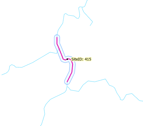
This tool builds reaches (polylines) from the input site layer in an upstream and downstream direction, with the site being at the centre of the reach. Such reaches could represent the limits of survey sites for which you want to compute slope

5 sites and their centred reaches.
Optional end points have also been extracted
The tool can process all sites or just a subset if a selection exists and you have ticked the Process only selected sites checkbox. The reach length can be a constant value or a value taken from a numeric field. Your site layer could potentially have a different downstream reach length for every site, or scaled in some manner (e.g. reach length scaled by Strahler order). Reach length values must be greater than zero and in metre units. If your network is in units of feet then RivEX will convert the metres value into feet.
It is possible for the desired reach length is not reached and the reach is flagged as Truncated. This happens if the site is close to a network mouth or source or you have ticked on clip by source ID.
If you have ticked on Clip downstream reach to Source ID. RivEX will honour the source ID encoded into the river network, with this option enabled RivEX will stop traversing in a downstream direction when it detects a change in source ID, this will likely truncate the reach. Further information on the influence of this parameter is found here.
Ticking on Extract reach end points will cause RivEX to extract out the end points (nodes) of the reaches into a separate dataset, this would be useful if you were intending to compute slope of the reach.
If you have ticked on Flip reach direction RivEX will flip the direction of the reach polyline once it has created it, tick this on if you require the reach polyline to flow in a sea to source direction.
Ticking on Buffer reach will cause RivEX to build a buffer for each reach. As with the reach itself a buffer can be a fixed width or a width value taken from a numeric field in the site layer. The buffer value must be greater than zero and in metre units. If your network is in units of feet then RivEX will convert the metres value into feet. Buffers are individually built, therefore adjacent reaches may create overlapping buffer polygons.
This example shows a site with its site-centred 500m reach and 50m buffer.
The reach and buffer inherit the site ID to allow you to automate further analysis
An attribute generated for each reach is sinuosity, computed as reach length divided by straight line path, an example is shown below.

If you have chosen to add to map (default) any Error log table created you can optionally get RivEX to construct a relate between it and the site layer to help you locate and deal with any sites that failed to process. Sites that fail to process are sites that are not intersecting the network or they intersect a network junction, these are skipped and require you to make a decision on which tributary they lie on and you need to move them.
Parameters
|
Name |
Help |
Data type |
|
River Network |
The river network. For best results the network should be within a File GeoDatabase |
Feature Layer |
|
Site layer |
A point layer for which you want to construct a downstream reach. This layer must conform to these specifications:
|
Feature Layer |
|
Site ID field |
This is a numeric (integer) field that uniquely identifying the sites. Text, Object ID or FID fields are not accepted. |
Field |
|
Process only selected sites |
Indicates if only selected sites are to be processed:
|
Boolean |
|
Reach length generated using |
This parameter allows you to switch between generating reaches using a constant length or use distances encoded into a field within the site layer. The options are:
|
String |
|
Distance (m) |
If the Reach length parameter was set to A Constant value then this parameter allows you to enter a positive number that is the length of the downstream reach to be built for each site. Values you enter must be greater than zero and represent metres. Warning: a site may not achieve this length if it is placed near a river network mouth. |
Double |
|
Distance field (m) |
If the Reach length parameter was set to A Distance from a field in the site layer then this parameter will allow you to choose a numeric field. Values within your chosen field must be greater than zero and represent metres. Warning: a site may not achieve this length if it is placed near a river network mouth. |
Field |
|
Clip downstream reach to source ID |
Indicates if RivEX honours the source ID as it travels downstream building the reach:
|
Boolean |
|
Extract reach end points |
Indicates if RivEX will extract the nodes of the reach:
If reach nodes are created then the Feature class will contain the following fields: "SiteID", "WhichEnd", "ReachLngth" |
Boolean |
|
Flip reach direction |
Indicates if RivEX will reverse of "flip" the reach polyline direction:
|
Boolean |
|
Buffer reach |
A check box used to indicate if you wish to run the optional buffering steps.
|
Boolean |
|
Reach buffer generated using |
This parameter allows you to switch between generating reach buffers using a constant length or use distances encoded into a field within the site layer. The options are:
|
String |
|
Buffer distance (m) |
If the reach buffer parameter was set to A Constant value then this parameter allows you to enter a positive number that is the constant buffer distance (m) of the reach to be built for each site. |
Double |
|
Buffer distance field |
If the reach buffer parameter was set to A Distance from a field in the site layer then this parameter will allow you to choose a numeric field from your site layer. Values within your chosen field must be greater than zero and in the units of the river network. |
Field |
|
Add an attribute index to output |
Indicates if RivEX will create an attribute index for the site ID field in the output layers
If you plan to join or relate data then it is STRONGLY recommended you create attribute indices for the outputs; an index can significantly speed up query operations. |
Boolean |
|
Add Error Log Table to Map |
If this is ticked (default) the error log table will be added to the map for your convenience if any errors were found. |
Boolean |
|
Build a Relate for Error Log |
If this tick box is checked then the error log table must be loaded into the map and RivEX builds a standard relate between the Error Log table and the river network layer. You can use the relate to help you jump to and review the error. |
Boolean |
Outputs
The main output of this tool is the reach feature class, if the tool successfully runs and reaches are generated these are added to the active map. You do not have control over the location or name of this dataset. It is written to the file geodatabase fGDB_Sites.gdb which is in the RivEX workspace folder ..\RivEX_Workspace\Outputs\ and the Feature Class takes on the name of site name + "_USDSReaches". The optional reach nodes datasets is written to the same file geodatabase but uses the output name site name + "_USDS_Reach_Nodes". The optional reach buffer datasets is written to the same file geodatabase but uses the output name site name + "_SiteCentredReachesBuffer". If any of these names exist then RivEX adds a numeric suffix to the Feature Class name.
If errors were generated then this tool creates a stand alone table named tblFailedSitesForUSDSReach. The table is created in the RivEX workspace folder and stored in the File GeoDatabase found in ..\RivEX_Workspace\ErrorLogs\fGDB_RivEXErrorLogs.gdb. If an error message An already traversed polyline RIVID XYZ was encountered. See help file. is reported then use the RivID value to locate the polyline and examine the network. It helps to have polyline direction symbolised to identify the polyline that is flowing in an up hill direction. You would need to flip the polyline direction and rebuild the topological information. You may need to recompute other RivEX generated attributes
Advice on the structure of the error log table and how it can be used is found within this section of the manual. Take note of the warning if you plan to construct a model using the error log output in subsequent processing.
The output reach feature class contains the following fields:
|
Field |
Description |
|
SiteID |
The Site ID the reach was built from |
|
Direction |
The direction the Reach was generated, this is always set to "BOTH" |
|
Truncated |
A Y/N flag to indicate if the reach was truncated |
|
PolylineID |
The polyline ID the site was intersecting |
|
Sinuosity |
The sinuosity of the reach, this is computed as reach length divided by straight line distance between its end points. |
The optional output nodes feature class contains the following fields:
|
Field |
Description |
|
SiteID |
The Site ID the reach was built from |
|
WhichEnd |
Which end of the reach the node is, this is always either "US" or "DS" |
|
ReachLength |
The length of the reach. This could potentially be shorter than the desired length due to truncation |
The optional output buffer feature class contains the following fields:
|
Field |
Description |
|
SiteID |
The Site ID the reach was built from |
|
Direction |
Which direction the reach was built in, this will always be "SC" for site-centred. |
|
BuffDist |
The buffer distance (m). If this came from a field in the site layer then each reach could potentially have a different buffer width. |
If you have selected the optional processing task, add attribute index, then the SiteID field in both output datasets will be indexed. An index can significantly speed up query operations such as joins or relates.
 Warnings
The network needs to be in units of metres or feet. Data in decimal degrees will yield invalid output.
This tool checks for stacked points in the input dataset and warns the user if any are found. It returns a count on the number of stacks found to give you a sense of the extent of the issue. RivEX will continue to process such data. If stacked locations are unexpected for your input data then it is recommend you quality control the input layer before continuing with your analysis.
With the release of ArcGIS Pro 3.2.1 a switch control appears on parameters that accept tables\feature classes, do not interact with it! More advice here.
When this tool is used in a script the river network parameter must be a full path to the Feature Class and not a layer object, see advice here.
Limitations
- This tool will not process data that has a latitude/longitude coordinate system (e.g. WGS84). You need to project your river network into a coordinate system that uses metres or feet.
- The site data cannot be a in-memory layer.
- Sites must be a simple point feature class, multi-point data is not allowed.
- This tool requires your network to be attributed with Source ID.
- The site layer must be in the same coordinate system as the river network.
- The site layer cannot have a join, you either need to remove the join or make it permanent.
Code sample
A minimum code example showing how to call this tool in a python script. This can be run in console or your preferred IDE. If you right click on the tool in the RivEX toolbox and select properties you can view parameter order.
import arcpy
# Import RivEX toolbox
arcpy.ImportToolbox(r"C:\RivEX_ArcPro\RivEX.atbx")
try:
# Input river Feature Class
fcRivers = r"C:\Scratch\ORN\data.gdb\ORN"
# Input sites Feature Class
fcSites = r"C:\Scratch\ORN\RivEX_Workspace\Outputs\fGDB_Sampling.gdb\fcSample_10K_spaced"
# Run RivEX tool, create a reach 1km upstream and downstream of site, clip to source ID, do not flip, extract end points, buffer or build an attribute index
# WARNING This tool will fail if river data is a layer with a selection! If you need to pass in selections use tool directly from toolbox
res = arcpy.scrCentredReaches_RivEX(fcRivers, fcSites, "SampleID", False, "A constant value", 1000, None, False, False, False, "A constant value", None, None, False, False, False)
# The reach Feature Class, a derived output
fcReach = res.getOutput(0)
# The end point Feature Class, a derived output
fcEndPoints = res.getOutput(1)
# The error table
tblError = res.getOutput(2)
# Check if error table exists
if arcpy.Exists(tblError):
# Count number of rows
res = arcpy.GetCount_management(tblError)
n = int(res.getOutput(0))
if n > 0:
print(str(n) + " error(s) were recorded")
else:
print("No error table created!")
res = arcpy.GetCount_management(fcReach)
n = int(res.getOutput(0))
print("Number of reaches created = " + str(n))
except arcpy.ExecuteError:
print("FAILED to build reaches!")
